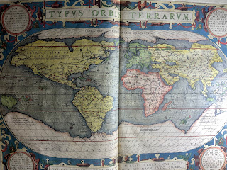
 What did the world look like in 1592? Abraham Ortelius's Theatrvm orbis terrarvum, or, Theater of the world attempts to answer that question. Cited as the first true modern atlas, Theatrvm was initially published in 1570 in Antwerp, the richest city in the world at the time. Earlier compilations of maps did exist, but this work's combination of the best available maps with textual description lacked precedent.
Our edition is the 19th, with Latin text and a whopping 134 maps. Each map was printed from copper plates engraved by the Antwerp artist Frans Hogenberg and his assistants. While not reflective of global geography as we now know it -- there are, for instance, only five continents in Ortelius's world -- they are a massive artistic achievement, hand-colored and decorated with allusions to Classical and biblical events. We particularly recommend the maps of the Holy Land, Ancient Egypt, and Iceland (which has the best sea monsters).
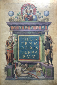
 Ultimately, this book is worth checking out for the title page alone. It features allegorical representations of the five known continents as women, and those images are just as fraught as the modern viewer might expect. We'll draw your eye to the smallest figure on the page -- only a bust of a woman where the other four have complete bodies. This is Terra Australis or Magellanica, the unknown but plenty theorized continent to the south. Europeans would not reach the (already inhabited) Australian continent until 1606, after which the idea of yet another unknown southern continent would persist until the discovery of Antarctica in the 19th century.
To take a look at Ortelius's world, ask for Rare Book G1006 .T5 1592.