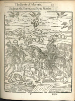
 What to do, what to do? How does a nobleman spend his time in 1611? We just acquired George Turbervile's The Book of Falconrie or Hawking for the Onely Delight and Pleasure of All Noblemen and Gentlemen (London: Thomas Purfoot, 1611) to answer just that question. The book provides detailed descriptions of the birds of prey suitable for the sport and methods for training and caring for them.
The hawking party depicted here shows the wealth and opulence associated with the sport. Falconry had been popular throughout Europe and Mesopotamia for centuries and its practice spread with the Norman conquest. Henry the VIII's enthusiasm made it all the rage with those who could afford it.
We couldn't help notice the fashion statement in these images. The blooming pants seem to evoke the feathered legs of birds of prey and the patterns a bird's plumage. Despite the probable lack of a causal relationship, the dual patterns of feathered finery are striking.
Our copy is bound with The Noble Art of Venerie or Hunting (London: Thomas Purfoot, 1611) also clearly intended for an elite audience. To see them ask for Rare SK321.T8 1611.

