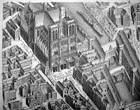
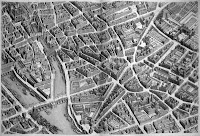
 One of the pleasures of working in Rauner Library is the "discovery" of things we never really appreciated. While preparing for a class session on French cultural history, we found a catalog listing for Turgot's ambitious Plan of Paris from 1739. The book contains 20 plates that fit together to create a detailed, bird's eye view of Paris as it was in 1739. The cartographers were given permission to enter any structure in Paris so they could accurately depict every feature of the city.
Curiously, the map is not laid out in the conventional north-south perspective. Instead, we see the city from the east. The reason? So the facades of the east-facing churches could be displayed. Fully assembled, the map would be approximately eight feet tall and ten feet wide.
Come see the atlas by requesting Rare Book G1844.P3 B7 1739. Kyoto University Library created an interactive digital version.

No comments:
Post a Comment