On January 16, 27 BC, the Roman Senate named Gauis Octavius, nephew of Julius Caesar, both Augustus and Princeps. The granting of these titles helped to cement Octavius's power in both the religious and political arenas of Rome and marked the beginning of the Roman Empire. But we don't want to talk about that. Instead, we'll move forward to 1776 and the publication of Gibbon's first volume of The History of the Decline and Fall of the Roman Empire (London: Printed for W. Strahan and T. Cadell in the Strand, 1776).
Gibbon's classic work attempted to chronicle the whole of the history of western civilization from 98 to 1590 AD, or roughly from the beginning of Trajan's imperium to late in Queen Elizabeth's reign. He discussed the decline of the Roman Empire in both the east and west and attributed the eventual fall to a gradual erosion of the will of the populace and a general malaise and antipathy toward current events. He argued that this led to the outsourcing of critical positions, most notably in the military, and to increased corruption in those same areas, all of which allowed for the eventual seizure of power by the German Odoacer in 476 - the first king of Italy.
Gibbon was fanatical about his source material and always preferred to use primary sources when possible, even when these sources contradicted history as promulgated by the Catholic Church. One notable example of this was Gibbon's claim that the number of Christians who suffered martyrdom at the hands of the Romans was much less than advertised. He cites writings by Origen and Dionysius of Alexandria, both of whom indicated that "the number of martyrs was very inconsiderable." Gibbon's further assertion that much of the decline was due to the rise of Christianity made for widespread criticism at the time.
To read Gibbon for yourself, ask for Val 874.42 G35ab.
Friday, January 16, 2015
Tuesday, January 13, 2015
Stumbled upon Maps
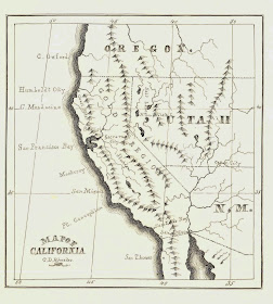
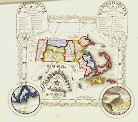
Wandering through various 1850’s documents held at Rauner, I came upon a small gathering of maps and drawings by students of the Brimmer School. According to Arthur W. Bayley's School and Schoolboys of Old Boston, "the Brimmer School for boys was established in 1843, to accommodate the surplus from the Adams, Winthrop, and Franklin Schools." The school was named to honor Martin Brimmer, mayor of Boston, 1843-1844.
The drawings date from an interesting period, particularly for the maps: 1859, just predating significant changes in the regions they depict, particularly the United States just prior to the Civil War. The map of Virginia includes territory that would break away from confederate Virginia in 1861 as the state of West Virginia, joining the Union in 1863, and becoming a pivotal border state during the Civil War.
The map of California does not show Nevada and Arizona, but rather the Utah and New Mexico territories bordering the state to the east. In 1861, the Confederate Territory of Arizona was created when southern New Mexico seceded from the Union. The state was recognized by Jefferson Davis in 1863, the first official use of the name Arizona. Formerly administered as part of the Utah territory, Nevada was separated from the territory in 1861, perhaps because of a population boom when silver was discovered in 1859, and, in 1864, became the second new state added to the Union during the war.
M. J. Byrne’s map of South America includes territories called New Granada and Buenos Ayres which by the middle of the 1860’s, would appear on maps as Columbia and the Argentine Republic. Also noted is Bolivia’s seacoast region with the port of Cobija, lost to Chile in the War of the Pacific, and making Bolivia a land-locked nation.
I assume these maps were drawn using existing published maps of the time. However, this brings us to the map of Massachusetts. One wonders what cartographer would decide to include totally-unrelated-to-Massachusetts vignettes of a volcano and the Ganges River.
To see the maps, ask for Rauner Ms 859900.5.